
As announced in our previous post, from the beginning of this month (March 2021), geodata and products from Federal Office of Topography (swisstopo) have been available on far less restrictive terms than previously.
As I noted then we didn’t have details available at the time so couldn’t comment further on the use of this data in OSM. In the meantime the terms are available and are limited to an attribution requirement which however applies downstream too. In the case of an use in OSM this would require products using our data to display attribution to swisstopo, this might seem to be an easy to fulfil requirement, but our licence specifically allows use that only credits the overall source of the data (that is the OpenStreetMap project). Considering the 100’s if not 1’000’s of 3rd party sources and 1.6 million individual contributors, this makes a lot of sense. But as a consequence this rules out direct use in OpenStreetMap till we have agreed alternative arrangements with swisstopo.
But it isn’t all gloom and doom, we have already agreed that we can make swisstopos high quality orthophoto product “swissimage” available in OSM editing apps and naturally applications that combine OSM and swisstopo, for example a map with swisstopo derived hill shading, is possible as long as swisstopo is credited.
It will take a bit until configuration updates have reached the major editors, if your favourite one supports custom imagery backgrounds from WMS servers you can add swissimage manually with
https://wms.geo.admin.ch/?FORMAT=image/vnd.jpeg-png8&TRANSPARENT=TRUE&VERSION=1.3.0&SERVICE=WMS&REQUEST=GetMap&LAYERS=ch.swisstopo.images-swissimage&STYLES=&CRS={proj}&WIDTH={width}&HEIGHT={height}&BBOX={bbox}
the above will work for JOSM, for Vespucci replace {proj} with EPSG:3857. The images are from flights in 2017 to 2020 (Map) in some cases we have access to cantonal imagery that is more recent. Please note that use of swisstopo infrastructure is subject to additional terms of use that should be respected.
To keep up with the developments, follow us on twitter @SwissOSM and subscribe to the Swiss OSM community mailing list.
Update September 14th 2021: swisstopo has now clarified that central attribution is acceptable for uses that combine many different data sources. See https://www.swisstopo.admin.ch/de/home/meta/konditionen/geodaten/source.html
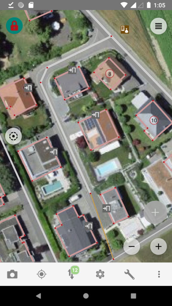
Background aerial imagery ©swisstopo, map data ©OpenStreetMap.
You can get the imagery into your existing Vespucci installation like this:
Wrench symbol -> More imagery tools… -> Update configuration
then
top-right -> (name of your previous imagery provider) -> Select imagery -> swisstopo SWISSIMAGE [wms]
Thank you to all those work for the reconciliation of OSM and SwissTopo data!
As a simple contributor, I see the advantage of being allowed to use these images with great precision.
I look forward to reading the next news on this subject and hope to be able to use these images soon.
Happy mapping !
Raphaël
Pingback: weeklyOSM 555 | weekly – semanario – hebdo – 週刊 – týdeník – Wochennotiz – 주간 – tygodnik
The Swisstopo imagery is incredible in my neighborhood, hiking path can be seen trough early spring tree cover.
That been said, we were pretty good without such a hi-res imagery so far. Great news from Swisstopo, but great, great job from the community before that!
Yves
Rather than WMS I would I use WMTS https://www.geo.admin.ch/en/geo-services/geo-services/portrayal-services-web-mapping/web-map-tiling-services-wmts.html
WMTS is not very well supported in OSMs editor ecosystem (actually there is currently only one editor in wider use that supports it). We could run a proxy if swisstopo believes it is necessary.