Use of swisstopo data and products with and in OpenStreetMap

As announced in our previous post, from the beginning of this month (March 2021), geodata and products from Federal Office of Topography (swisstopo) have been available on far less restrictive terms than previously.

As I noted then we didn’t have details available at the time so couldn’t comment further on the use of this data in OSM. In the meantime the terms are available and are limited to an attribution requirement which however applies downstream too. In the case of an use in OSM this would require products using our data to display attribution to swisstopo, this might seem to be an easy to fulfil requirement, but our licence specifically allows use that only credits the overall source of the data (that is the OpenStreetMap project). Considering the 100’s if not 1’000’s of 3rd party sources and 1.6 million individual contributors, this makes a lot of sense. But as a consequence this rules out direct use in OpenStreetMap till we have agreed alternative arrangements with swisstopo.

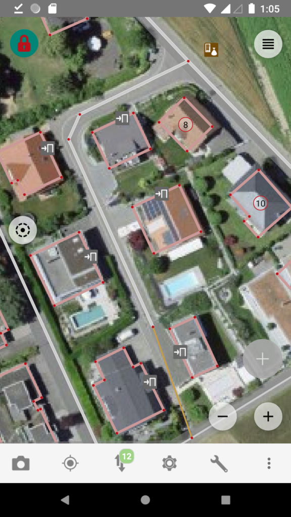
But it isn’t all gloom and doom, we have already agreed that we can make swisstopos high quality orthophoto product “swissimage” available in OSM editing apps and naturally applications that combine OSM and swisstopo, for example a map with swisstopo derived hill shading, is possible as long as swisstopo is credited.

It will take a bit until configuration updates have reached the major editors, if your favourite one supports custom imagery backgrounds from WMS servers you can add swissimage manually with

https://wms.geo.admin.ch/?FORMAT=image/vnd.jpeg-png8&TRANSPARENT=TRUE&VERSION=1.3.0&SERVICE=WMS&REQUEST=GetMap&LAYERS=ch.swisstopo.images-swissimage&STYLES=&CRS={proj}&WIDTH={width}&HEIGHT={height}&BBOX={bbox}

the above will work for JOSM, for Vespucci replace {proj} with EPSG:3857. The images are from flights in 2017 to 2020 (Map) in some cases we have access to cantonal imagery that is more recent. Please note that use of swisstopo infrastructure is subject to additional terms of use that should be respected.

To keep up with the developments, follow us on twitter @SwissOSM and subscribe to the Swiss OSM community mailing list.

Update September 14th 2021: swisstopo has now clarified that central attribution is acceptable for uses that combine many different data sources. See https://www.swisstopo.admin.ch/de/home/meta/konditionen/geodaten/source.html

Background aerial imagery ©swisstopo, map data ©OpenStreetMap.

SOSM Annual General Meeting April 7th 2018 Solothurn

The 2018 AGM will take place in Solothurn on April the 7th, 11:00. The venue is at the

Amt für Geoinformation
Rötistrasse 4
4501 Solothurn

Many thanks to SOGIS for supporting us

The event will follow our proven formula with a roughly one hour formal part starting at 11:00, with lunch following and a fairly unstructured mapping party as the activity in the afternoon from 13:30 onwards.

Guests, including such that simply want to learn something about OpenStreetMap, are welcome to both parts. Could however both members and guests indicate to info@sosm.ch if they plan to attend, particularly for lunch, so that we can inform the restaurant how many guests they can expect.

Agenda for the 2018 Swiss OpenStreetMap Association Annual General Meeting

Saturday, April 7th 2018, 11:00,

Amt für Geoinformation, Rötistrasse 4, 4501 Solothurn

1. Opening and Welcome

2. Election of the minute taker and vote counters

3. Adoption of minutes of the 2017 AGM

4. Activity report 2017

5. Financial results 2017

– Presentation by the treasurer
– Auditors report

6. Discharge of the Board

7. Membership fees 2018

8. Budget 2018

9. Elections

– Board
Candidates for all positions are welcome.

– Auditors

10. Any other business

Metanet donates hard disks to SOSM

Some of the SAS (this is a fast computer interface similar to SATA) disks we received together with the servers that we run osm.ch and related services on, have failed due to old age, and while we originally had an ample supply of spares now we’ve now run out.

Unfortunately, these disks are rather expensive to purchase new, if not to say uneconomic. Luckily Metanet has now helped us out by donating eight 2nd hand disks from their stock. This will allow us to defer a complete replacement for at least 1 to 2 years and make an unhurried decision on what to buy.

A big thank you to Metanet for supporting the Swiss OpenStreetMap Association.

Building addresses of canton Bern

Like Simon has already noted in a previous blog entry, we may use the Building Addresses of the Canton of Bern (GEBADR) for OSM.

In the last months the data was prepared to be suitable for OSM and a tasking manager was set up. Further information can be found in the documentation on the OSM wiki about this project.

Some are already mapping the addresses and are drawing the missing building outlines. But the task is rather large with a total of 400’000 addresses and it will take a long time. Further mappers supporting this project would therefore be really welcome. So please spread the word!

A special thank to Michael Spreng for his support and setting up the tasking manager. The tasking manager was set up on the servers of SOSM and is now available for other projects as well.

SOSM is now an OSMF Local Chapter

When we founded SOSM in June 2012 one of the topics was if we should aspire to becoming a formal local chapter of the OSMF. At the time it wasn’t urgent since the OSMF hadn’t actually finalised a template agreement or actually accepted a local chapter, it took nearly another 3 years for the first chapter to be admitted (Iceland early in 2015).

In 2012 and every time we had discussed the matter at an AGM the SOSM board had made clear that we would hold a members vote when the time was ripe and that took place at our AGM in April of this year. Still even with the approval of our members it has taken us another 5 months to actually get the agreement signed at the global State of the Map conference last week.

img_1284

We don’t expect any drastic change with this step, however given that so much of our work deals with government offices, political and other advocacy groups, having “official” status cannot hurt. The other part of the equation is that the agreement gives us a formal licence to use OpenStreetMap and other related trademarks in Switzerland.

Looking forward we expect to see more collaboration with other local chapters going forward and expect them to grow in importance as stakeholders in the project.