About Simon

Simon is the current SOSM president http://sosm.ch/about/board/simon-poole/

Use of swisstopo data and products with and in OpenStreetMap

As announced in our previous post, from the beginning of this month (March 2021), geodata and products from Federal Office of Topography (swisstopo) have been available on far less restrictive terms than previously.

As I noted then we didn’t have details available at the time so couldn’t comment further on the use of this data in OSM. In the meantime the terms are available and are limited to an attribution requirement which however applies downstream too. In the case of an use in OSM this would require products using our data to display attribution to swisstopo, this might seem to be an easy to fulfil requirement, but our licence specifically allows use that only credits the overall source of the data (that is the OpenStreetMap project). Considering the 100’s if not 1’000’s of 3rd party sources and 1.6 million individual contributors, this makes a lot of sense. But as a consequence this rules out direct use in OpenStreetMap till we have agreed alternative arrangements with swisstopo.

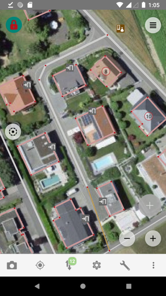
But it isn’t all gloom and doom, we have already agreed that we can make swisstopos high quality orthophoto product “swissimage” available in OSM editing apps and naturally applications that combine OSM and swisstopo, for example a map with swisstopo derived hill shading, is possible as long as swisstopo is credited.

It will take a bit until configuration updates have reached the major editors, if your favourite one supports custom imagery backgrounds from WMS servers you can add swissimage manually with

https://wms.geo.admin.ch/?FORMAT=image/vnd.jpeg-png8&TRANSPARENT=TRUE&VERSION=1.3.0&SERVICE=WMS&REQUEST=GetMap&LAYERS=ch.swisstopo.images-swissimage&STYLES=&CRS={proj}&WIDTH={width}&HEIGHT={height}&BBOX={bbox}

the above will work for JOSM, for Vespucci replace {proj} with EPSG:3857. The images are from flights in 2017 to 2020 (Map) in some cases we have access to cantonal imagery that is more recent. Please note that use of swisstopo infrastructure is subject to additional terms of use that should be respected.

To keep up with the developments, follow us on twitter @SwissOSM and subscribe to the Swiss OSM community mailing list.

Update September 14th 2021: swisstopo has now clarified that central attribution is acceptable for uses that combine many different data sources. See https://www.swisstopo.admin.ch/de/home/meta/konditionen/geodaten/source.html

Background aerial imagery ©swisstopo, map data ©OpenStreetMap.

Welcome swisstopo!

Today we are welcoming the Swiss Federal Office of Topography (swisstopo) to the open data community. After many years of free access for consumers, today, finally, it is providing reusable open government data that can be used to build and enrich new applications and datasets.

This is a high point of a development of open data availability in Switzerland in which the cantons have been leading for many years starting with the Canton Solothurn over a decade ago and is now policy in nearly all of them.

What does this mean for OpenStreetMap?

Short term nothing is going to change. While at the time I’m writing this we don’t have access to the final terms of use, we do have a good idea of what the content will be and some of the terms will not be completely compatible with our distribution licence, the ODbL. This rules out direct inclusion in our data, but will allow use as reference data for quality assurance. We are negotiating with swisstopo for compatible access terms, just as we have previously done for the municipality administrative boundaries way back in 2011 and more recently for use of the GWR address data and expect these issues to be resolved soon.

The most interesting data for us right now is access to swisstopos “swissimage” aerial imagery. This will at last provide us with good coverage in Switzerland’s mountainous regions, something that has been sorely missing from the global orthophoto mosaics.

To keep up with the developments, follow us on twitter @SwissOSM and subscribe to the Swiss OSM community mailing list.

Map image ©swisstopo

AGM online May 16th 2020 11:00

Participation and voting (BigBlueButton, link was sent by mail to all members)

  1. Opening and Welcome
  2. Election of the minute taker and vote counters
  3. Adoption of minutes of the 2019 AGM
  4. Activity report 2019
  5. Financial results 2019
    • Presentation by the treasurer
    • Auditors report
  6. Discharge of the Board
  7. Membership fees 2021
  8. Budget 2020
  9. Amendment of the articles of association
    • Introduction of honorary members
  10. Appointment of honorary members
  11. Elections
    • Board
      Candidates for all positions are welcome. All existing board members are standing
      for re-election.
    • Auditors
  12. Any other business

Allianz faires Urheberrecht

Der Vorstand der SOSM hat diese Woche beschlossen, die Allianz für ein faires Urheberrecht in der Schweiz zu unterstützen.

Auch wenn wir von der am meist diskutierten vorgeschlagene Änderung, die “Linksteuer” nicht direkt betroffen wären, scheint es uns nicht sinnvoll Regelungen einzuführen die, zugunsten von einzelnen Unternehmungen, versuchen die Zeit zurück zudrehen, und in diesem spezifischen Fall auch noch handwerklich katastrophal sind.

Die weniger besprochene weitere Änderung, die Einführung eines Äquivalents des Lichtbildschutz, den wir aus anderen europäischen Ländern kennen, betrifft uns aber direkt.

Bisher hatte die Schweiz eine sehr hohe Hürde, die überwunden werden musste um einen urheberrechtlichen Schutz einer Fotographie zu erhalten (Bundesgerichtsurteil “Meili Foto” ). Dies wird nun ins Gegenteil gekehrt, mit dem Resultat, dass man davon ausgehen muss, dass auch automatisch und mechanisch aufgenommene Bilder in Zukunft geschützt sind (also Luftbilder, StreetView, Mapillary und so weiter) und ebenso daraus abgeleitete Werke nur noch mit der Erlaubnis des jeweiligen Rechteinhabers erstellt werden dürfen. Der Bundesrat schliesst dies zwar in seiner Botschaft zur Revision aus, der Gesetzestext selber scheint aber dazu im Widerspruch zu stehen.

Auf jeden Fall ist die Rechtssicherheit für uns bei der Benutzung solcher Quellen nicht mehr vorhanden, was nicht in unserem Interesse sein kann.

2019 Swiss OpenStreetMap Association Annual General Meeting

The 2019 AGM will take place in Basel on Saturday March the 30th, 11:00.

The venue is at the

BORROMÄUM
Clubzimmer
Byfangweg 6
CH-4051 Basel

The event will follow our proven formula with a roughly one hour formal part starting at 11:00, with lunch following and a fairly unstructured mapping party as the activity in the afternoon from 13:30 onwards.

Guests, including such that simply want to learn something about OpenStreetMap, are welcome to both parts.

Could however both members and guests indicate to info@sosm.ch if they plan to attend, particularly for lunch, so that we can inform the restaurant how many guests they can expect.

Looking forward to seeing you in Basel.


Agenda for the 2019 Swiss OpenStreetMap Association Annual General Meeting

Agenda der Generalversammlung der Swiss OpenStreetMap Association 2019


Saturday, March 30th 2019, 11:00,
Samstag, den 30. März 2019, 11:00,


BORROMÄUM, Clubzimmer, Byfangweg 6, CH-4051 Basel

1. Opening and Welcome / Eröffnung und Begrüssung
2. Election of the minute taker and vote counters / Wahl des Protokollführers & der Stimmenzähler
3. Adoption of minutes of the 2018 AGM / Annahme des Protokolls der GV 2018
4. Activity report 2018 / Tätigkeitsbericht 2018
5. Financial results 2018 / Jahresrechnung 2018
– Presentation by the treasurer / Bericht des Kassiers
– Auditors report / Bericht der Kassenprüfer
6. Discharge of the Board / Entlastung des Vorstandes
7. Membership fees 2019 / Mitgliederbeiträge 2019
8. Budget 2019
9. Elections / Wahlen
– Board / Vorstand
Candidates for all positions are welcome.
Kandidaten für alle Positionen sind willkommen.
– Auditors / Kassenprüfer
10. Any other business / Varia

SOSM is now an OSMF Local Chapter

When we founded SOSM in June 2012 one of the topics was if we should aspire to becoming a formal local chapter of the OSMF. At the time it wasn’t urgent since the OSMF hadn’t actually finalised a template agreement or actually accepted a local chapter, it took nearly another 3 years for the first chapter to be admitted (Iceland early in 2015).

In 2012 and every time we had discussed the matter at an AGM the SOSM board had made clear that we would hold a members vote when the time was ripe and that took place at our AGM in April of this year. Still even with the approval of our members it has taken us another 5 months to actually get the agreement signed at the global State of the Map conference last week.

img_1284

We don’t expect any drastic change with this step, however given that so much of our work deals with government offices, political and other advocacy groups, having “official” status cannot hurt. The other part of the equation is that the agreement gives us a formal licence to use OpenStreetMap and other related trademarks in Switzerland.

Looking forward we expect to see more collaboration with other local chapters going forward and expect them to grow in importance as stakeholders in the project.

Building Addresses Canton Berne

As you may remember early this year we got permission to use the open address data from the Canton Berne in OpenStreetMap, this after a couple of years back and forth due to the new cantonal legislation and older usage terms that sounded as if the data might be usable but in reality didn’t allow it.

The address data is available from the cantonal open data portal however it is rather unwieldly (a good 400’000 addresses) and problematic to handle even in JOSM. I foolhardly promised to do something about that at the time, but didn’t get around to doing anything up to now. It should be noted that nobody has stepped forward and volunteered to organize an import of any kind, so my focus is simply proving it as reference data that can be used at a small-scale.

While my current solution is not perfect and will likely see improvements over time (for example the layer is currently opaque), it is probably  the best solution for now. I’ve produced a background layer from the data that shows

  • usage
  • house
  • street/place

josm-bern2


To reduce clutter I’ve shortened some of the usage strings:

  • Wohnhaus – WH
  • Bauernhaus – BH
  • Garage – G
  • Scheune – S
  • Gebäude – B

The data is hosted on sourcepoles QGIS Cloud system, many thanks to Marco and his team for supporting us. To make things simpler for iD users and work around some issues JOSM has with WMS servers we actually proxy this through our mapproxy instance.

The relevant tile URL is:

http://mapproxy.osm.ch:8080/tiles/GEBADRBE/EPSG900913/{z}/{x}/{y}.png?origin=nw

Please add a clear indication of the source in your changesets if you use this data.

Translating osm.ch

new_osmch

Thanks to efforts of Michael (datendelphin) the move of the SOSM
provided services to the new SOSM servers in Bern is nearly complete.

See http://sosm.ch/wikimedia-donates-old-toolservers-to-sosm/ and
http://sosm.ch/adfinis-offers-hosting-location/

As part of the move I’ve updated the osm.ch portal a bit and added the
ability to pull translations from transifex. Up to now the portal was
only in German, I’ve added an English version leaving French, Italian
and Romansh to do.

The transifex project can be found here
https://www.transifex.com/projects/p/osmch/

Given that there are currently only 43 strings, I fully expect that we
will have the missing three languages covered tomorrow :-).

On a more serious note we are always looking for people that can help
with the translation of content on sosm.ch which is currently
predominantly German and English. If you want to help send us a mail to
board@sosm.ch

Update: translations for all aditional languages were done by Friday the 24th of April!

Just 20’000 left to go …

Two years and a couple of months back I started running daily street name completeness checks for Switzerland. See my original article for more information, information on the changes for 2014 (this article points out some of the quality issues with the GWR) and http://qa.poole.ch/ch-roads/ for the daily updates.

On the 12th of March we passed the 100’000 street name mark implying that in 27 months we have added nearly 40’000 names that were previously missing or unverified, leaving roughly 20’000 to go.

GWR 2014-12-01* OSM 2012-11-01 OSM 2013-12-27 OSM 2015-03-12 %
Roads 121’041 62’258 87’759 100’012 83%
Other 63’673 14’101 8’598 12’465 20%

* the GWR values are corrected for the issues discussed in the December 2013 blog post and are not the raw numbers. This is the reason for the decrease in numbers of non-road objects.

Naturally I do not expect to reach the 100% mark any time soon. There is quite a high number of municipalities that do not sign post their roads, making independent verification very difficult to impossible (this is not the same as not having street names in the first place which is not a problem) and naturally these places don’t tend to be where hot spots of OSM contributors are. On the other hand there is still a lot of very low hanging fruit which simply needs verification. Low hanging in this case means that the roads in question can already be found in OSM, but there are simply spelling differences that we need to investigate (see the original article on how to handle differences between the GWR and reality).

Please don’t forget the 2015 SOSM Donation Drive to enable us to continue to operate this and other services.


March 2015

December 2013

January 2013


2015 SOSM AGM and Mapping Party, Saturday April 18th 2015 (Updated March 18th)

SOSM  will be holding its 2015 AGM in Bienne/Biel, 11:00 at the Lago Lodge . We intend to follow the same format as previous years: short formal part, lunch and then some mapping. Agenda and venue will be announced by mid March.

Non-SOSM members are welcome, if you want to attend the meeting and/or lunch please send mail to info@sosm.ch since space is likely to be limited.