Building Addresses Canton Berne

As you may remember early this year we got permission to use the open address data from the Canton Berne in OpenStreetMap, this after a couple of years back and forth due to the new cantonal legislation and older usage terms that sounded as if the data might be usable but in reality didn’t allow it.

The address data is available from the cantonal open data portal however it is rather unwieldly (a good 400’000 addresses) and problematic to handle even in JOSM. I foolhardly promised to do something about that at the time, but didn’t get around to doing anything up to now. It should be noted that nobody has stepped forward and volunteered to organize an import of any kind, so my focus is simply proving it as reference data that can be used at a small-scale.

While my current solution is not perfect and will likely see improvements over time (for example the layer is currently opaque), it is probably  the best solution for now. I’ve produced a background layer from the data that shows

  • usage
  • house
  • street/place

josm-bern2


To reduce clutter I’ve shortened some of the usage strings:

  • Wohnhaus – WH
  • Bauernhaus – BH
  • Garage – G
  • Scheune – S
  • Gebäude – B

The data is hosted on sourcepoles QGIS Cloud system, many thanks to Marco and his team for supporting us. To make things simpler for iD users and work around some issues JOSM has with WMS servers we actually proxy this through our mapproxy instance.

The relevant tile URL is:

http://mapproxy.osm.ch:8080/tiles/GEBADRBE/EPSG900913/{z}/{x}/{y}.png?origin=nw

Please add a clear indication of the source in your changesets if you use this data.

Missing Crosswalks – A MapRoulette Challenge

Take part of this MapRoulette Challenge which is about checking if there’s a pedestrian street crossing (crosswalk) or not. This verification goes on until it’s all done. MapRoulette is a kind of gamified website and a mapping campaign similar to MapZen’s targeted editing series.

image

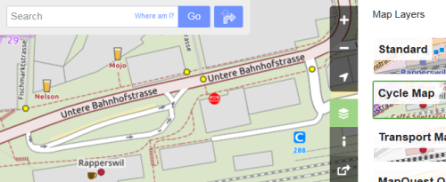
Once integrated in OpenStreetMap (OSM), crosswalks are shown in web maps (e.g. OSM Cycle Map/OSM Radfahrerkarte/OpenCycleMap, OSM France and OSM2World). And they are useful for pedestrian navigation apps (like OsmAnd).

So help OpenStreetMap to improve this missing information!

image

Figure 1: Cycle map from OpenStreetMap main page showing pedestrian street crossings (crosswalks) as yellow dot markers.

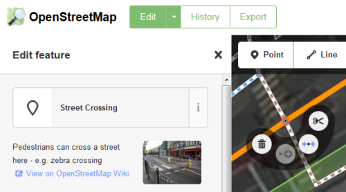
A crosswalk node needs to be placed as part of a way. It requires the tag highway=crossing (search for “Crossing” e.g. in built-in online editor “iD”). For the capture of other attributes like the existence of islands or traffic signals see Key:crossing on OSM Wiki.

Important notes: When using editor “iD” the presets suggest tag crossing=zebra. This tag is mainly used in UK. Since this challenge is in Switzerland you can delete this tag. Finally: When saving, a changeset comment is needed. You can use there e.g. “Missing Crosswalks Challenge”.

image

Figure 2: A “Street Crossing” node shown in the online editor “iD” built-in OpenStreetMap main page.

The street crossings (crosswalks) in fact are coordinates our automated process found in aerial images by using a parallel image detection algorithm. This new software works mainly with yellow crossings of Switzerland on aerial images with certain quality at zoom level 18.

The coordinate data around eastern Switzerland has been extracted at December, 2nd. 2015. This covers about a tenth of the total area of Switzerland.

Contact us if you have questions or ideas around this hot topic.

Happy mapping!

This article was originally published on geometalab.

SOSM 2015 Annual General Meeting

Agenda for the 2015 Swiss OpenStreetMap Association Annual General Meeting

Saturday, April 18th 2014, 11am,Lago Lodge, Uferweg 5, CH-2560 Nidau

  1. Opening and Welcome
  2. Election of the minute taker and vote counters
  3. Adoption of minutes of the 2014 AGM
  4. Activity report 2014
  5. Financial results 2014 –
    • Presentation by the treasurer
    • Auditors report
  6. Membership fees 2015
  7. Budget 2015
  8. Elections
    • Board (candidates for all positions are welcome.)
    • Auditors (note Otto Wyss will no longer be available)
  9. Trade registry registration
  10. Application for OSMF Local Chapter Status
  11. Any other business

Wikimedia Germany donates old Toolservers to SOSM

New serversOn Friday we drove 870 km to Haarlem in the vicinity of Amsterdam to pick up three servers. Wikimedia has decommissioned their two year old toolservers and donated the hardware to SOSM. Thanks to Wikimedia Germany and Wikimedia Switzerland for making this possible.

This will enable us to run our services on our own hardware in Switzerland. Support the move by contributing to the SOSM donation drive 2015.

2015 SOSM Donation Drive

umap_screenshotDear friends of OpenStreetMap and SOSM

As you may know, SOSM provides a range of services for the Swiss OpenStreetMap community. Currently this is financed for a major part out of our regular membership fees, this however limits some aspects of our operations quite considerably. All services are currently run on a single, small leased server in Germany.

In 2015 we would like to

  • move all services to a hosting location in Switzerland
  • provide better performing and redundant hardware for our most popular services (map tiles, uMap and routing)
  • expand our OSM data and imagery hosting offerings (for example the current imagery covering the Canton Aargau)

While we have the prospect of a number of in-kind donations to support the above, more on that soon, there is still the need for additional funds to cover cash outlays. Example: while we have a computer hardware donation arranged, the hardware will have to be imported and VAT on its value paid, just this single item would be substantially outside of SOSMs current annual budget.

To support the plans for this year SOSM board has therefore decided to explicitly ask for donations to SOSM in 2015 with the goal of collecting at least CHF 5000 over the course of the year.

Donations can made to

Postfinance account
85-53542-9
IBAN CH54 0900 0000 8505 3542 9

Swiss OpenStreetMap Association
Heitersbergstrasse 1
8962 Bergdietikon
Switzerland

Please note 2015 DONATION DRIVE on the payment. By default we will be publishing the names of all donors, if you don’t want to be mentioned, please add that either to you payment information or send mail to info@sosm.ch.

2015 SOSM AGM and Mapping Party, Saturday April 18th 2015 (Updated March 18th)

SOSM  will be holding its 2015 AGM in Bienne/Biel, 11:00 at the Lago Lodge . We intend to follow the same format as previous years: short formal part, lunch and then some mapping. Agenda and venue will be announced by mid March.

Non-SOSM members are welcome, if you want to attend the meeting and/or lunch please send mail to info@sosm.ch since space is likely to be limited.

MapProxy Service Update

We’ve updated the imagery available via the SOSM mapproxy service to include more recent imagery for Solothurn and the recently releast imagery for the city of Berne. The imagery for the canton Solothurn is a mosaic of imagery between 2011 and 2014 provided by the cantonal GIS office SOGIS, replacing the old 2007 and 2011 orthophotos.

Together with the new AGIS imagery, the above has been added to the central OSM imagery index and should be available in iD, P2 and vespucci soon.

If you can’t wait, the imagery is available via the following pseudo URLs:

Berne:

http://mapproxy.osm.ch:8080/tiles/bern2012/EPSG900913/{zoom}/{x}/{y}.png?origin=nw

Solothurn:

http://mapproxy.osm.ch:8080/tiles/sogis2014/EPSG900913/{zoom}/{x}/{y}.png?origin=nw


Updated Aerial Imagery for the Canton Aargau

agis2014

As already indicated on the Swiss OSM mailing list SOSM has obtained the most recent imagery from the cantonal GIS office of the canton Aargau (AGIS). The imagery was recorded in July 2014 which on the one hand makes it very current, on the other implies that there is more foliage visible than on the 2011 imagery.

The imagery is available with the following pseudo URL for entry in OSM editors

http://mapproxy.osm.ch:8080/tiles/AGIS2014/EPSG900913/{z}/{x}/{y}.png?origin=nw

I’ll be adding the configuration to the central imagery repositories as soon as possible.

The tiles from this imagery were produced slightly differently than the previous ones with not quite satisfactory results from a visual point of view. It is possible that I might rerun the tiling later once we have some feedback.

SOSM will be running a donation drive soon to cover the costs of the imagery and a build out of our services, however please feel free to donate now (account details, please indicate if mentioning your name is allowed), your support if very much appreciated.

A thank you to the Hochschule Rapperswil and Stefan Keller for helping us with actually uploading the 190GB of data to the SOSM server.