Missing Crosswalks – A MapRoulette Challenge

Take part of this MapRoulette Challenge which is about checking if there’s a pedestrian street crossing (crosswalk) or not. This verification goes on until it’s all done. MapRoulette is a kind of gamified website and a mapping campaign similar to MapZen’s targeted editing series.

image

Once integrated in OpenStreetMap (OSM), crosswalks are shown in web maps (e.g. OSM Cycle Map/OSM Radfahrerkarte/OpenCycleMap, OSM France and OSM2World). And they are useful for pedestrian navigation apps (like OsmAnd).

So help OpenStreetMap to improve this missing information!

image

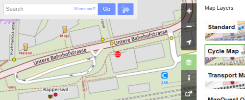
Figure 1: Cycle map from OpenStreetMap main page showing pedestrian street crossings (crosswalks) as yellow dot markers.

A crosswalk node needs to be placed as part of a way. It requires the tag highway=crossing (search for “Crossing” e.g. in built-in online editor “iD”). For the capture of other attributes like the existence of islands or traffic signals see Key:crossing on OSM Wiki.

Important notes: When using editor “iD” the presets suggest tag crossing=zebra. This tag is mainly used in UK. Since this challenge is in Switzerland you can delete this tag. Finally: When saving, a changeset comment is needed. You can use there e.g. “Missing Crosswalks Challenge”.

image

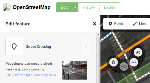
Figure 2: A “Street Crossing” node shown in the online editor “iD” built-in OpenStreetMap main page.

The street crossings (crosswalks) in fact are coordinates our automated process found in aerial images by using a parallel image detection algorithm. This new software works mainly with yellow crossings of Switzerland on aerial images with certain quality at zoom level 18.

The coordinate data around eastern Switzerland has been extracted at December, 2nd. 2015. This covers about a tenth of the total area of Switzerland.

Contact us if you have questions or ideas around this hot topic.

Happy mapping!

This article was originally published on geometalab.

SOSM 2015 Annual General Meeting

Agenda for the 2015 Swiss OpenStreetMap Association Annual General Meeting

Saturday, April 18th 2014, 11am,Lago Lodge, Uferweg 5, CH-2560 Nidau

  1. Opening and Welcome
  2. Election of the minute taker and vote counters
  3. Adoption of minutes of the 2014 AGM
  4. Activity report 2014
  5. Financial results 2014 –
    • Presentation by the treasurer
    • Auditors report
  6. Membership fees 2015
  7. Budget 2015
  8. Elections
    • Board (candidates for all positions are welcome.)
    • Auditors (note Otto Wyss will no longer be available)
  9. Trade registry registration
  10. Application for OSMF Local Chapter Status
  11. Any other business

2015 SOSM Donation Drive

umap_screenshotDear friends of OpenStreetMap and SOSM

As you may know, SOSM provides a range of services for the Swiss OpenStreetMap community. Currently this is financed for a major part out of our regular membership fees, this however limits some aspects of our operations quite considerably. All services are currently run on a single, small leased server in Germany.

In 2015 we would like to

  • move all services to a hosting location in Switzerland
  • provide better performing and redundant hardware for our most popular services (map tiles, uMap and routing)
  • expand our OSM data and imagery hosting offerings (for example the current imagery covering the Canton Aargau)

While we have the prospect of a number of in-kind donations to support the above, more on that soon, there is still the need for additional funds to cover cash outlays. Example: while we have a computer hardware donation arranged, the hardware will have to be imported and VAT on its value paid, just this single item would be substantially outside of SOSMs current annual budget.

To support the plans for this year SOSM board has therefore decided to explicitly ask for donations to SOSM in 2015 with the goal of collecting at least CHF 5000 over the course of the year.

Donations can made to

Postfinance account
85-53542-9
IBAN CH54 0900 0000 8505 3542 9

Swiss OpenStreetMap Association
Heitersbergstrasse 1
8962 Bergdietikon
Switzerland

Please note 2015 DONATION DRIVE on the payment. By default we will be publishing the names of all donors, if you don’t want to be mentioned, please add that either to you payment information or send mail to info@sosm.ch.

Our server now supports SSL

Our new umap service made quite a good start. We had quite positive feedback from several people. But there was also a problem reported by Adfinis: They added a map to their home page using umap. Now when the homepage is was with SSL the browser denied the embedding of umap which was without SSL (known as mixed content blocking). And not only did they make us aware of the problem, they even offered to pay for the necessary SSL certificate. Thank you for sponsoring the certificate!

We now support SSL on our sites, for example https://umap.osm.ch.

High Resolution Aerial Imagery from the City of Zürich

zh-luftbild-beispiel

A couple of weeks back the city of Zürich expanded the available layers on its public WMS server to include areal imagery of the city from multiple years. Of particular interest to us is the 2011 data which is clearly superior to what has been available up to now and is a lot better georeferenced. This will allow us to address some of the issues we have in central Zürich and is a huge leap forward from the Bing/Yahoo imagery we’ve had until now.

We hope that this sets yet another example for other Swiss cities and cantons, to open up their WMS servers. SOSM will continue to negotiate with other cantons and cities (see http://sosm.ch/projects/cantonal-aerial-imagery/ for progress).

Many thanks to the GIS office of Zürich!

Using the imagery in your editor

For JOSM users the WMS server can be queried with

http://www.gis.stadt-zuerich.ch/maps/services/wms/WMS-ZH-STZH-OGD/MapServer/WMSServer

For P2 and iD users we have added the layer to our mapproxy configuration and it can be accessed (with placeholders) with:

P2: http://mapproxy.sosm.ch:8080/tiles/zh_luftbild2011/EPSG900913/$z/$x/$y.png?origin=nw

iD: http://mapproxy.sosm.ch:8080/tiles/zh_luftbild2011/EPSG900913/{z}/{x}/{y}.png?origin=nw


uMap Instance for Switzerland

It has been a long time in the making, but at last, we are happy to announce that a SOSM hosted uMap instance is available: umap.osm.ch .

uMap allows you to create hosted map configurations that contain base maps, data sources and manual annotations.

An example of what can be done with very little effort: the “Swiss style” map with car sharing locations queried from the Overpass API.


See full screen

While the data displayed in the example is static, the same can be done with a direct query of the OverPass API or similar sources. Data that is limited to Switzerland can be retrieved from the SOSM Overpass service, and to make that a bit easier we now have a local Overpass Turbo instance.

To create your own map on umap.osm.ch you simply need an account on www.openstreetmap.org and allow umap.osm.ch access to it.

A special thank you to Sarah for setting up the system for us and to Yohan Boniface for developing uMap.

Mapping Party Burgdorf April 5th 13:30

burgdorfAs already announced we will be going out and mapping after the SOSM AGM on Saturday and after we have had lunch (please feel free to join us for that too).

Meeting location: Restaurant Schützenhaus, Wynigenstrasse 13, Burgdorf

Burgdorf itself is fairly well mapped with only a few roads missing and a handful of name spellings that need to be verified http://qa.poole.ch/ch-roads/BE/404.html . However the surroundings, in particular Kirchberg are fairly undermapped. Kirchberg can easily be reached by Bus, the rest of the villages likely will require a bicycle or other means of transport.

Rough schedule:

  • Meetup 13:30
  • Mapping starts 14:00
  • Back at Restaurant 16:00
  • Data entry etc.
  • Dinner roughly 18:00 (for those that choose to stay)


SOSM 2014 Annual General Meeting

The 2014 Annual General Meeting of the Swiss OpenStreetMap Association which will take place on Saturday, April 5th 2014, 11am in the Restaurant Schützenhaus, Wynigenstrasse 13, Burgdorf

[mapsmarker marker=”1″]

You will find the full agenda here.

After the meeting there will be an informal lunch and a mapping party. If you already know that you will be attending, could you please indicate so for planning purposes by e-mail to info@sosm.ch

We hope to see many of you in Burgdorf.