This tour is a series of events to celebrate the 20th anniversary of OpenStreetMap (OSM) and its impact on communities around the world and in Switzerland. Participants will learn about the versatility of OpenStreetMap and its central role in supporting sectors such as tourism and emergency services. Join us as we celebrate two decades of collaborative mapping, innovation and the transformative power of open data. Some events will take place online, others onsite – with a “grand” finale on the actual birthday around August 9, 2024!
Three onsite events at which Swiss OSM was a guest have already taken place, namely Wikipedia Day 2024 on April 27, 2024 in Bern, the workshop “OpenStreetMap for Research and Geospatial Analysis” on May 16, 2024 at the University of Zurich and the “Sozial- und Umweltforum Ostschweiz” (SUFO) on May 25, 2024 in St. Gallen.
The online webinar series on “OpenStreetMap for fire departments and other interested parties” (in German) on May 14 and 23, 2024 was also very successful. Next up is the webinar series on “OpenStreetMap for tourism – using POIs correctly” (also online and in German) on June 19 and June 25, 2024.
Share these events! Contact me (Stefan Keller) for any questions about this tour.
Stefan Keller von der OST Ostschweizer Fachhochschule und SOSM-Vorstandsmitglied wird “Mapper in Residence” bei der Stadt Winterthur für vier Freitage im November 2023 (*).
Als Mapper in Residence (MiR)…
dient er als Bindeglied zwischen einer Organisation – in diesem Fall der Abteilung Geoinformation der Stadt Winterthur – und der OpenStreetMap (OSM) Community.
fördert er das Verständnis für OpenStreetMap unter den Mitarbeitenden der Organisation, z.B. durch Veranstaltungen.
fördert er die Verbesserung von OpenStreetMap-Inhalten und -Prozessen durch die Community.
Ein:e Mapper in Residence initiiert bzw. stärkt letztlich die Partnerschaft zwischen der Organisation und der OpenStreetMap-Community. Das kleine Projekt ist inspiriert von “The Wikipedian in Residence”.
Stefan Keller wird unter anderem Daten und Prozesse identifizieren und Werkzeuge verbessern und spezifizieren. Dies um mehr offene Daten der Stadt Winterthur in OpenStreetMap zu integrieren und um diese in OpenStreetMap aktuell zu halten. Dies könnte auch zu einer Verbesserung und Erweiterung des “Leitfadens für Dateneigentümer” (**) von 2021 führen.
(*) Siehe auch diese Mitteilung auf LinkedIn der Stadt Winterthur vom 30. Oktober 2023. (**) Hitz-Gamper, B. S., & Stürmer, M. E. (2021). Daten in OpenStreetMap integrieren – ein Leitfaden für Dateninhaber. DOI: 10.48350/159438. Download (PDF).
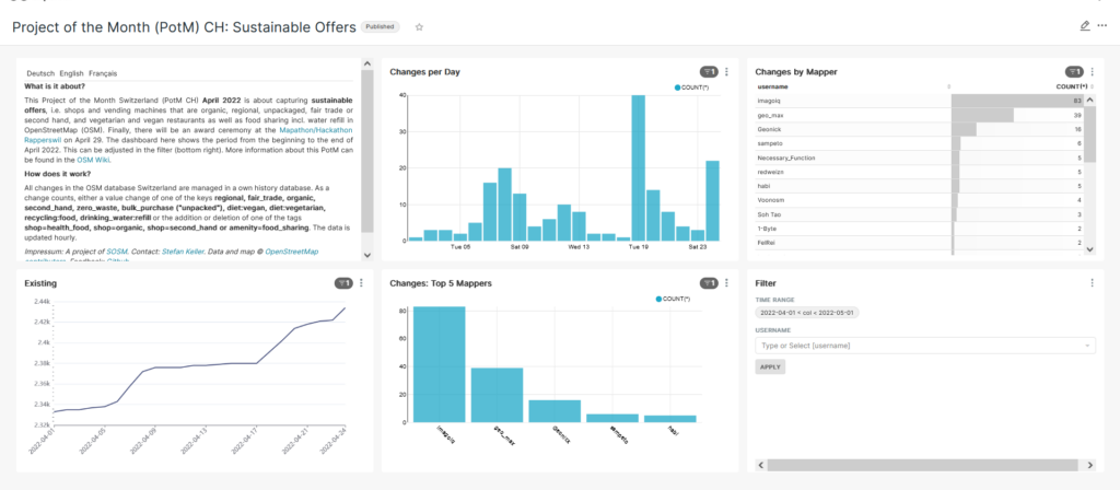
The “Project of the Month Switzerland” (PotM CH) of April 2022 is about the collection of sustainable offers, i.e. stores and vending machines that are organic, regional, unpackaged, fair trade or second hand, and vegetarian and vegan restaurants as well as food sharing including water refill. Note the relevant tags and keys in the PotM documentation [1]. The “Sustainable” web map [2] by user ToastHawaii nicely depicts most of the items.
Dashboard and Ranking
The April 2022 PotM-CH dashboard was given the number 19 [3]. As before, it shows a ranked list of the mapper names that have edited the most. By the way, users geo_max and Geonick, currently ranked second and third, are out of contention. So currently imagoiq, sampeto and Necessary_Function are on the first three places.
Prizes and Mapathon/Hackathon 29 April 2022
The April 2022 PotM CH is a very special promotion with prizes to be won: The three most diligent mappers will receive small gift boxes from the farm! The prizes will be awarded at the Mapathon/Hackathon Rapperswil 2022, which will take place next Friday afternoon, April 29 [4]. There are still places available at this Mapathon/Hackathon (“Ask us Anything”).
Sustainability Week Rapperswil 2022
The PotM CH prizes and pizza and drinks from the Mapathon were sponsored by Sustainability Week Rapperswil 2022 (NHWR22). Here is the whole program of the #NHWR22 [5].
What does “sustainable” mean?
The term “sustainable” has been defined rather restrictively in this PotM. It actually means much more, such as free repair offers, car and bike sharing, or environmentally sound waste disposal. Much of this has already been proposed in the PotM documentation [2] and could be done in the next months.
Have an idea for a “Project of the Month”?
If you have an idea for a PotM CH, just post it in the documentation/wiki [1] or get in touch on one of the channels mentioned in the help here [6].
Now the time has come: The “Project of the Month Switzerland”, short PotM CH, has started! The idea is to work together on a specific OpenStreetMap (OSM) topic. This way, mappers can be made aware of a topic and newcomers to a topic can be introduced to OSM. It is also used for targeted data improvement (“Directed Data Collection”). The idea for this comes from the French “Projet du mois” and the German “Schwerpunkt der Woche”, among others.
Wiki page for PotM CH and PotM CH Dashboard
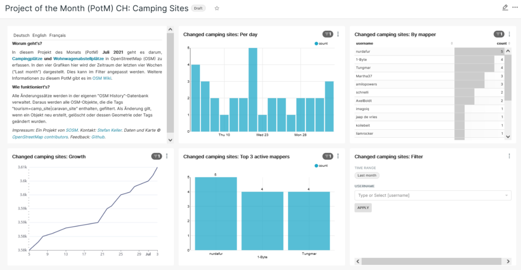
A wiki page for PotM CH [1] has now been set up and a PotM CH webapp [2] implemented. The wiki page explains again what it is about and the PotM CH webapp shows in a dashboard with charts the active mappers and the progress.
PotM CH July 2021 Campsites and RV parks
PotM CH July 2021 is about campgrounds and RV sites. Use the tag “tourism=camp_site” for campgrounds and the tag “tourism=caravan_site” for RV sites. More tips can be found on the wiki page for PotM CH [1] (in german and french). Important: Always tag changesets with #potmch!
Next actions and StreetComplete and MapComplete
The next actions are already planned and you can participate and suggest further actions or topics! Just edit the mentioned wiki page [1]. If you want to do pioneer work, you can also configure StreetComplete or MapComplete! On the wiki page for PotM CH you can find the corresponding help.
Join the PotM CH July 2021 campsites! Who will make it to the podium in July?
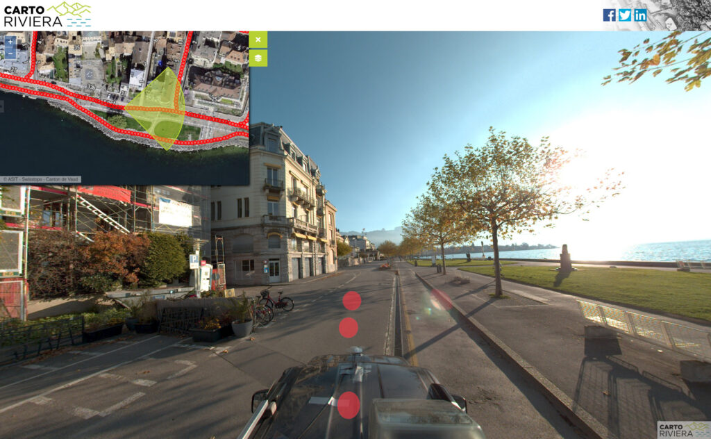
The city of Vevey has published on the Cartoriviera portal the data from a “mobile mapping” survey that took place at the end of last year. The 45 km of Vevey’s road network was covered and images were taken every 3 metres (people and license plates were blurred).
This data is freely available on the Internet https://cartoriviera.ch/rues-vevey, and these images are available for digitisation. Use the following source in the changesets based on this data:
Today we are welcoming the Swiss Federal Office of Topography (swisstopo) to the open data community. After many years of free access for consumers, today, finally, it is providing reusable open government data that can be used to build and enrich new applications and datasets.
This is a high point of a development of open data availability in Switzerland in which the cantons have been leading for many years starting with the Canton Solothurn over a decade ago and is now policy in nearly all of them.
What does this mean for OpenStreetMap?
Short term nothing is going to change. While at the time I’m writing this we don’t have access to the final terms of use, we do have a good idea of what the content will be and some of the terms will not be completely compatible with our distribution licence, the ODbL. This rules out direct inclusion in our data, but will allow use as reference data for quality assurance. We are negotiating with swisstopo for compatible access terms, just as we have previously done for the municipality administrative boundaries way back in 2011 and more recently for use of the GWR address data and expect these issues to be resolved soon.
The most interesting data for us right now is access to swisstopos “swissimage” aerial imagery. This will at last provide us with good coverage in Switzerland’s mountainous regions, something that has been sorely missing from the global orthophoto mosaics.
On Sunday, October 4, 2020, 25 Swiss castles invite you to the 5th National Castles Day. Their gates and drawbridges will then be open from 10 am to 5 pm for a varied program. So – come on in!
The association Wikimedia CH and the Swiss OpenStreetMap association (SOSM) will complement the event with a Swiss Fortresses Day 2020 (Burgentag 2020). Young and old medieval enthusiasts alike are invited to discover a castle ruin on their own. You decide the program yourself. Every castle has a history and many have something mystical about them. And there is often a fireplace nearby. Find out more with the following tips:
Map with selected castle ruins sites (see picture below),
A photo challenge to upload missing photos of castles.
Illustration: Interactive online map of selected castle ruins (realized with uMap and with OpenStreetMap data). [Large map]
The photo challenge is simple: Work through this list of castle objects without pictures and upload the photos to Wikimedia Commons! For each uploaded photo there is a tweet (from @trending_places) with the hashtag #CastleProject. The photo is then usually immediately visible on the Castles project map.
The interactive online map of selected castle ruins shows a hand-picked selection of castles in Switzerland that are freely accessible and easy to reach. Depending on the castle, it can be up to one kilometer (i.e. approx. 20 min.) or more away from the nearest public transport stop or parking lot. Please follow the signs and treat nature with respect (e.g. make sure that there is no danger of forest fires in the area, watch out for ticks, don’t leave litter).
The map contains only a small part of the castles and palaces as they are managed in the Castles Project Switzerland. The Castles project links open data directly from the four open data projects OpenStreetMap, Wikipedia, Wikidata and Wikimedia Commons (photos).
The Swiss Burgentag 2020 was initiated by the SOSM association and Wikimedia CH. The event is also kindly supported by the Swiss Castle Association. We thank the association ‘Die Schweizer Schlösser’ for agreeing to link the two action days Swiss Castles Day and Burgentag 2020.
As already mentioned at last year’s AGM, we got a new server, and we have now taken this server into operation. Thank you to Init7 for sponsoring the hosting of this server.
The new server enables us to now render OSM data worldwide.